
Mund topographic map
Interactive map
Click on the map to display elevation.
About this map
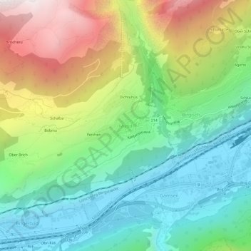
Name: Mund topographic map, elevation, terrain.
Location: Mund, Naters, Brigue, Valais, 3903, Suisse (46.29529 7.92110 46.33529 7.96110)
Average elevation: 1,250 m
Minimum elevation: 650 m
Maximum elevation: 2,353 m
Other topographic maps
Click on a map to view its topography, its elevation and its terrain.
Monte Leone
Suisse > Valais > Brigue > Zwischbergen
Monte Leone, Zwischbergen, Brigue, Valais, 3907, Suisse
Average elevation: 2,818 m