
Thank you for supporting this site ❤️
Make a donation
Make a donation
Lluchmayor topographic map
Click on the map to display elevation.
Thank you for supporting this site ❤️
Make a donation
Make a donation
About this map
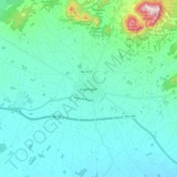
Name: Lluchmayor topographic map, elevation, terrain.
Location: Lluchmayor, Migjorn, Islas Baleares, 07620, España (39.45085 2.85132 39.53085 2.93132)
Average elevation: 164 m
Minimum elevation: 88 m
Maximum elevation: 545 m
Thank you for supporting this site ❤️
Make a donation
Make a donation
Other topographic maps
Click on a map to view its topography, its elevation and its terrain.