
Thank you for supporting this site ❤️
Make a donation
Make a donation
Castiglione Messer Raimondo topographic map
Click on the map to display elevation.
Thank you for supporting this site ❤️
Make a donation
Make a donation
About this map
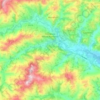
Name: Castiglione Messer Raimondo topographic map, elevation, terrain.
Location: Castiglione Messer Raimondo, Teramo, Abruzzo, 64034, Italy (42.48873 13.82825 42.55444 13.92297)
Average elevation: 292 m
Minimum elevation: 121 m
Maximum elevation: 554 m
Thank you for supporting this site ❤️
Make a donation
Make a donation
Other topographic maps
Click on a map to view its topography, its elevation and its terrain.
Thank you for supporting this site ❤️
Make a donation
Make a donation
Thank you for supporting this site ❤️
Make a donation
Make a donation