
Thank you for supporting this site ❤️
Make a donation
Make a donation
Revelstoke topographic map
Click on the map to display elevation.
Thank you for supporting this site ❤️
Make a donation
Make a donation
Revelstoke
A small ski resort featuring a single short lift has operated on Mount MacKenzie since the 1960s, and snowcat skiing was offered for higher altitudes. A strong movement pushed to expand the entire mountain into a single resort, and construction started in the early 2000s (decade).
Thank you for supporting this site ❤️
Make a donation
Make a donation
About this map
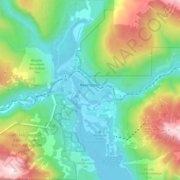
Name: Revelstoke topographic map, elevation, terrain.
Average elevation: 982 m
Minimum elevation: 431 m
Maximum elevation: 2,427 m
Thank you for supporting this site ❤️
Make a donation
Make a donation
Other topographic maps
Click on a map to view its topography, its elevation and its terrain.
McMurdo
Canada > British Columbia > Columbia-Shuswap Regional District > Area A (Kicking Horse/Kinbasket Lake)
Average elevation: 852 m