
Dêqên County topographic map
Interactive map
Click on the map to display elevation.
About this map
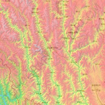
Name: Dêqên County topographic map, elevation, terrain.
Location: Dêqên County, Diqing, Yunnan, China (27.55823 98.59286 29.22572 99.52114)
Average elevation: 3,590 m
Minimum elevation: 1,022 m
Maximum elevation: 6,429 m
Being located at an altitude of 3,300 metres (10,800 ft), Dêqên lies in the transition between a subtropical highland climate (Köppen Cwb) and humid continental climate (Köppen Dwb), which is remarkable for its latitude. Although mean maximum temperatures, as in Lhasa and Shigatse, stay above freezing year-round, minima are below freezing from November to March, and temperatures average −1.4 °C (29.5 °F) in January, 13.6 °C (56.5 °F) in July, while the annual mean is 6.32 °C (43.4 °F). The town is nonetheless a little warmer during the winter than Shangri-La County to the east despite being slightly higher in elevation, due to its more southerly aspect. Rainfall is concentrated between June and September, accounting for nearly 60% of the annual total of 640 mm (25.2 in); snowfall is rare but still causes major transport problems in the winter. With monthly percent possible sunshine ranging from 29% in July to 62% in December, the county seat receives 1,989 hours of bright sunshine annually, with autumn and winter sunnier than spring and summer.
Other topographic maps
Click on a map to view its topography, its elevation and its terrain.
Yingjiang County
China > Yunnan > Yingjiang County
Yingjiang County, Dehong, Yunnan, 665000, China
Average elevation: 1,428 m
Nuozhadu Dam
China > Yunnan > Lancang Lahu Autonomous County
Nuozhadu Dam, Lancang Lahu Autonomous County, Pu'er City, Yunnan, China
Average elevation: 843 m
Dali Bai Autonomous Prefecture
Dali Bai Autonomous Prefecture, Yunnan, China
Average elevation: 2,168 m
Dulong
China > Yunnan > Maguan County
Dulong, Maguan County, Wenshan, Yunnan, China
Average elevation: 1,321 m
Jinghong City
Jinghong City, Xishuangbanna, Yunnan, 666100, China
Average elevation: 1,120 m
Manle
China > Yunnan > Mengla County
Manle, Mengla County, Xishuangbanna, Yunnan, 666100, China
Average elevation: 744 m
Wanbi
China > Yunnan > Dayao County > Wanbi
Wanbi, Dayao County, Chuxiong Yi Autonomous Prefecture, Yunnan, China
Average elevation: 1,485 m
Dabanqiao Subdistrict
Dabanqiao Subdistrict, Guandu District, Kunming, Yunnan, 650211, China
Average elevation: 2,093 m
Honghe Hani and Yi Autonomous Prefecture
Honghe Hani and Yi Autonomous Prefecture, Yunnan, 661300, China
Average elevation: 1,502 m
Diqing
China > Yunnan > Dêqên Tibetan Autonomous Prefecture > Jiantang
Diqing, Jiantang, Shangri-La County, Dêqên Tibetan Autonomous Prefecture, Yunnan, 674400, China
Average elevation: 3,328 m
Molong
China > Yunnan > Luoping County > Molong
Molong, Luoping County, Qujing City, Yunnan, China
Average elevation: 1,922 m