
Make a donation
Mexico City topographic map
Click on the map to display elevation.
Make a donation
Mexico City
Mexico City (Spanish: Ciudad de México, locally [sjuˈða(ð) ðe ˈmexiko] ; abbr.: CDMX; Nahuatl: Āltepētl Mēxihco, Nahuatl pronunciation: [aːl'tepeːt͡ɬ meːˈʃiʔko]; Otomi: 'Monda) is the capital and largest city of Mexico, and the most populous city in North America. Mexico City is one of the most important cultural and financial centers in the world. It is located in the Valley of Mexico within the high Mexican central plateau, at an altitude of 2,240 meters (7,350 ft). The city has 16 boroughs or demarcaciones territoriales, which are in turn divided into neighborhoods or colonias.
Make a donation
About this map
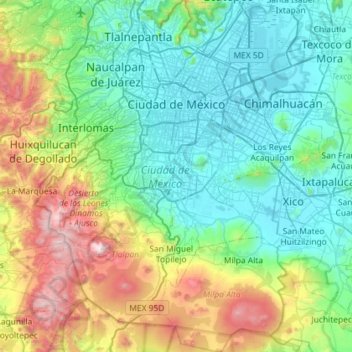
Name: Mexico City topographic map, elevation, terrain.
Location: Mexico City, Mexico (19.04872 -99.36492 19.59276 -98.94030)
Average elevation: 2,619 m
Minimum elevation: 2,223 m
Maximum elevation: 3,915 m
Make a donation
Other topographic maps
Click on a map to view its topography, its elevation and its terrain.