
Shoshone County topographic map
Interactive map
Click on the map to display elevation.
About this map
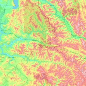
Name: Shoshone County topographic map, elevation, terrain.
Location: Shoshone County, Idaho, United States of America (46.93071 -116.32997 48.06772 -114.95879)
Average elevation: 1,204 m
Minimum elevation: 623 m
Maximum elevation: 2,280 m
Other topographic maps
Click on a map to view its topography, its elevation and its terrain.
Boise
United States of America > Idaho > Boise
Boise, Ada County, Idaho, 83702, United States of America
Average elevation: 1,040 m
Ada County
United States of America > Idaho
Ada County, Idaho, United States of America
Average elevation: 1,004 m
Lake Pend Oreille
United States of America > Idaho > Cedar Creek
Lake Pend Oreille, National Forest Development Road 278, Cedar Creek, Bonner County, Idaho, 83803, United States of America
Average elevation: 941 m
Lemhi County
United States of America > Idaho
Lemhi County, Idaho, United States of America
Average elevation: 2,146 m