
Make a donation
Oruro topographic map
Click on the map to display elevation.
Make a donation
Oruro
Oruro lies north of the salty lakes Uru Uru and Poopó. It is three hours (by vehicle) from La Paz. Located at an altitude of 3709 meters above sea level, Oruro is well known for its cold weather. Warmer temperatures generally take place during August, September and October, after the worst of the winter chills and before the summer rains. From May to early July, night-time temperatures combined with a cold wind can bring the temperature down to well below freezing. Summers are warmer, and, although it is an arid area, it has considerable rainfall between November and March. The Köppen climate classification describes the climate as a cold subtropical highland climate, abbreviated Cfb, with winter precipitation not low enough for a Cwb designation. Due to the warm days and dry winters, snow is not a frequent occurrence as much as the bitter cold (especially at night); however, flurries can fall usually once every few years, most recently July 4, 2015. The other three most recent snowfalls were those of 13 June 2013, 1 September 2010 (with accumulation), as well as one in 2008.
Make a donation
About this map
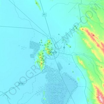
Name: Oruro topographic map, elevation, terrain.
Location: Oruro, Municipio Oruro, Provincia Cercado, Oruro, Bolivia (-18.12984 -67.27483 -17.80984 -66.95483)
Average elevation: 3,751 m
Minimum elevation: 3,697 m
Maximum elevation: 4,481 m
Make a donation