
Peermade topographic map
Click on the map to display elevation.
Peermade
The landscape of Peermade includes spectacular waterfalls, open grass lands and pine forests. Predominantly it is classified as Malanad with an elevation ranging from 3,000 ft (910 m) from the mean sea level.
About this map
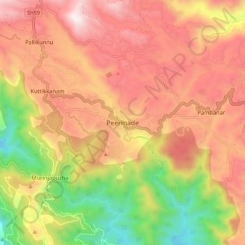
Name: Peermade topographic map, elevation, terrain.
Location: Peermade, Peerumade, Idukki, Kerala, 685531, India (9.53201 76.95590 9.61201 77.03590)
Average elevation: 918 m
Minimum elevation: 300 m
Maximum elevation: 1,399 m
Other topographic maps
Click on a map to view its topography, its elevation and its terrain.
Periyar National Park Tiger Reserve
Periyar National Park lies in the middle of a mountainous area of the Cardamom Hills. In the north : The boundary commences from the point nearest to the Medaganam in the interstate boundary up to Vellimalai. and the east Thence the boundary follows the inter-state boundary from Vellimalai to Kallimalai Peak…
Average elevation: 929 m