
Thank you for supporting this site ❤️
Make a donation
Make a donation
Hillsdale topographic map
Click on the map to display elevation.
Thank you for supporting this site ❤️
Make a donation
Make a donation
About this map
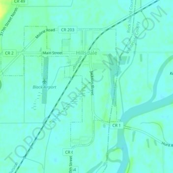
Name: Hillsdale topographic map, elevation, terrain.
Location: Hillsdale, Rock Island County, Illinois, United States (41.59886 -90.19081 41.61776 -90.16578)
Average elevation: 178 m
Minimum elevation: 173 m
Maximum elevation: 192 m
Thank you for supporting this site ❤️
Make a donation
Make a donation
Other topographic maps
Click on a map to view its topography, its elevation and its terrain.
Moline
United States > Illinois > Rock Island County > Moline
Moline witnessed a continued population increase after World War II with the completion of "Molette", a subdivision of mass-produced starter homes selling for $5,000 each. Molette was the first Moline neighborhood produced on a mass scale and one of the largest single-unit housing projects in the Midwest at…
Average elevation: 210 m