
Thank you for supporting this site ❤️
Make a donation
Make a donation
Petit Mont Blanc topographic map
Click on the map to display elevation.
Thank you for supporting this site ❤️
Make a donation
Make a donation
About this map
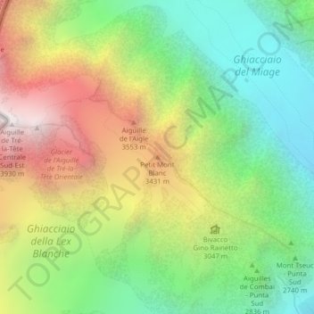
Name: Petit Mont Blanc topographic map, elevation, terrain.
Location: Petit Mont Blanc, Courmayeur, Aosta Valley, Italy (45.79172 6.83292 45.79182 6.83302)
Average elevation: 2,908 m
Minimum elevation: 2,205 m
Maximum elevation: 3,910 m
Thank you for supporting this site ❤️
Make a donation
Make a donation
Other topographic maps
Click on a map to view its topography, its elevation and its terrain.