
Thank you for supporting this site ❤️
Make a donation
Make a donation
Mountlake Terrace topographic map
Click on the map to display elevation.
Thank you for supporting this site ❤️
Make a donation
Make a donation
Mountlake Terrace
The city sits on a plateau that is elevated from the surrounding landscape, with views of the Olympic and Cascade mountains. The Mountlake Terrace's elevation ranges from 263 to 528 feet (80 to 161 m) above sea level, with an average altitude of 440 feet (130 m). The southwestern portion of the city includes the 100-acre (40 ha) Lake Ballinger, which is fed by Hall Creek from Lynnwood and discharges into McAleer Creek towards Lake Washington. Other portions of Mountlake Terrace lie in the watersheds of Lyon Creek and Swamp Creek, which both drain into Lake Washington.
Thank you for supporting this site ❤️
Make a donation
Make a donation
About this map
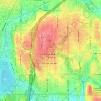
Name: Mountlake Terrace topographic map, elevation, terrain.
Average elevation: 121 m
Minimum elevation: 77 m
Maximum elevation: 162 m
Thank you for supporting this site ❤️
Make a donation
Make a donation