
Thank you for supporting this site ❤️
Make a donation
Make a donation
Kendu Bay topographic map
Click on the map to display elevation.
Thank you for supporting this site ❤️
Make a donation
Make a donation
About this map
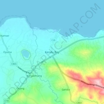
Name: Kendu Bay topographic map, elevation, terrain.
Location: Kendu Bay, Homa Bay County, Nyanza, Kenya (-0.40660 34.61000 -0.32660 34.69000)
Average elevation: 1,168 m
Minimum elevation: 1,131 m
Maximum elevation: 1,338 m
Thank you for supporting this site ❤️
Make a donation
Make a donation
Other topographic maps
Click on a map to view its topography, its elevation and its terrain.