
Thank you for supporting this site ❤️
Make a donation
Make a donation
Pontarlier topographic map
Click on the map to display elevation.
Thank you for supporting this site ❤️
Make a donation
Make a donation
Pontarlier
Nestled in the heart of the Jura Mountains near the Swiss border, the town lies along the Doubs River and occupies the Arlier plain at approximately 830–837 m elevation. It is overshadowed by the Grand Taureau peak, which reaches 1,323 m.
Thank you for supporting this site ❤️
Make a donation
Make a donation
About this map
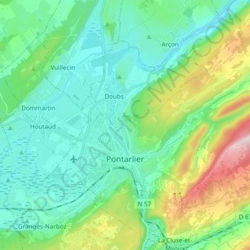
Name: Pontarlier topographic map, elevation, terrain.
Average elevation: 906 m
Minimum elevation: 784 m
Maximum elevation: 1,293 m
Thank you for supporting this site ❤️
Make a donation
Make a donation
Other topographic maps
Click on a map to view its topography, its elevation and its terrain.