
Thank you for supporting this site ❤️
Make a donation
Make a donation
Lac Brûlé topographic map
Click on the map to display elevation.
Thank you for supporting this site ❤️
Make a donation
Make a donation
About this map
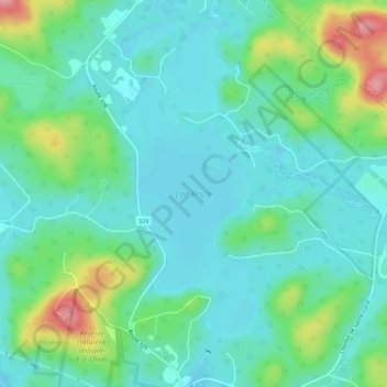
Name: Lac Brûlé topographic map, elevation, terrain.
Average elevation: 391 m
Minimum elevation: 360 m
Maximum elevation: 487 m
Thank you for supporting this site ❤️
Make a donation
Make a donation
Other topographic maps
Click on a map to view its topography, its elevation and its terrain.
Mont Sainte-Agathe
Canada > Quebec > Les Laurentides > Sainte-Agathe-des-Monts
Average elevation: 448 m