
Thank you for supporting this site ❤️
Make a donation
Make a donation
Gan Yavne topographic map
Click on the map to display elevation.
Thank you for supporting this site ❤️
Make a donation
Make a donation
About this map
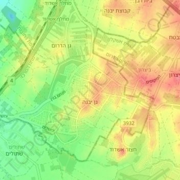
Name: Gan Yavne topographic map, elevation, terrain.
Location: Gan Yavne, Rehovot Subdistrict, Center District, Israel (31.76972 34.66972 31.81125 34.73165)
Average elevation: 41 m
Minimum elevation: 7 m
Maximum elevation: 73 m
Thank you for supporting this site ❤️
Make a donation
Make a donation
Other topographic maps
Click on a map to view its topography, its elevation and its terrain.
Thank you for supporting this site ❤️
Make a donation
Make a donation
Modiin-Maccabim-Reut
Israel > Center District > Ramla Subdistrict > Modiin-Maccabim-Reut
Average elevation: 240 m
Thank you for supporting this site ❤️
Make a donation
Make a donation