
Thank you for supporting this site ❤️
Make a donation
Make a donation
Bridgeton topographic map
Click on the map to display elevation.
Thank you for supporting this site ❤️
Make a donation
Make a donation
About this map
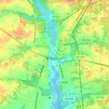
Name: Bridgeton topographic map, elevation, terrain.
Average elevation: 18 m
Minimum elevation: -3 m
Maximum elevation: 35 m
Thank you for supporting this site ❤️
Make a donation
Make a donation
Other topographic maps
Click on a map to view its topography, its elevation and its terrain.
West Creek
United States > New Jersey > Cumberland County > Maurice River Township
Average elevation: 5 m
Willis Corner
United States > New Jersey > Cumberland County > Stow Creek Township
Average elevation: 11 m
Greenwich
United States > New Jersey > Cumberland County > Greenwich Township > Greenwich
Average elevation: 2 m
Thank you for supporting this site ❤️
Make a donation
Make a donation