
Thank you for supporting this site ❤️
Make a donation
Make a donation
Le Marin topographic map
Click on the map to display elevation.
Thank you for supporting this site ❤️
Make a donation
Make a donation
About this map
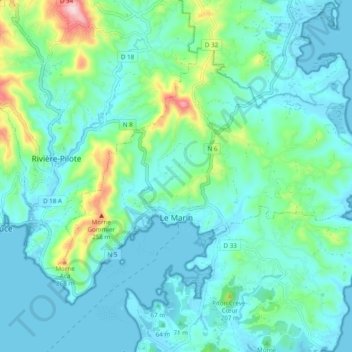
Name: Le Marin topographic map, elevation, terrain.
Location: Le Marin, Martinique, 97290, France (14.44788 -60.90745 14.51659 -60.81034)
Average elevation: 67 m
Minimum elevation: 0 m
Maximum elevation: 363 m
Thank you for supporting this site ❤️
Make a donation
Make a donation
Other topographic maps
Click on a map to view its topography, its elevation and its terrain.