
Thank you for supporting this site ❤️
Make a donation
Make a donation
St. Peter topographic map
Click on the map to display elevation.
Thank you for supporting this site ❤️
Make a donation
Make a donation
About this map
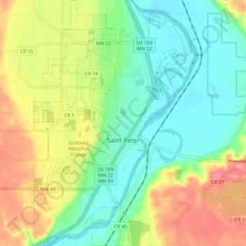
Name: St. Peter topographic map, elevation, terrain.
Location: St. Peter, Nicollet County, Minnesota, 56082, United States (44.29745 -93.98977 44.35864 -93.93336)
Average elevation: 261 m
Minimum elevation: 222 m
Maximum elevation: 325 m
Thank you for supporting this site ❤️
Make a donation
Make a donation
Other topographic maps
Click on a map to view its topography, its elevation and its terrain.
Riverbend Estates
United States > Minnesota > Nicollet County > North Mankato
Average elevation: 265 m