
Thank you for supporting this site ❤️
Make a donation
Make a donation
Dilworth topographic map
Click on the map to display elevation.
Thank you for supporting this site ❤️
Make a donation
Make a donation
About this map
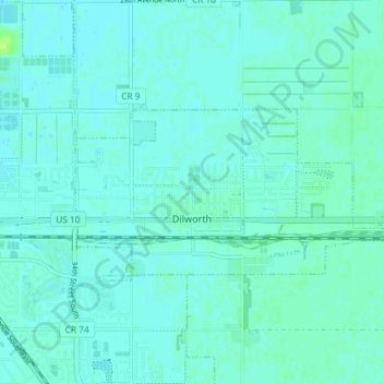
Name: Dilworth topographic map, elevation, terrain.
Location: Dilworth, Clay County, Minnesota, 56529, United States (46.86932 -96.72573 46.89099 -96.65236)
Average elevation: 278 m
Minimum elevation: 275 m
Maximum elevation: 286 m
Thank you for supporting this site ❤️
Make a donation
Make a donation
Other topographic maps
Click on a map to view its topography, its elevation and its terrain.
Thank you for supporting this site ❤️
Make a donation
Make a donation
confluence of Red River of the North and Buffalo River
United States > Minnesota > Clay County
Average elevation: 268 m