
Make a donation
Ozalj topographic map
Click on the map to display elevation.
Make a donation
About this map
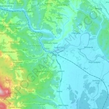
Name: Ozalj topographic map, elevation, terrain.
Location: Ozalj, Grad Ozalj, Karlovac County, 47281, Croatia (45.57263 15.43789 45.65263 15.51789)
Average elevation: 179 m
Minimum elevation: 108 m
Maximum elevation: 504 m
Make a donation
Other topographic maps
Click on a map to view its topography, its elevation and its terrain.
Jasenak
A weather station exists there at an elevation of 618 metres (2,028 ft). The minimum recorded temperature for the winter of 2024–2025 was −16.7 °C (1.9 °F), on February 20.
Average elevation: 884 m
Make a donation
Jasenak
A weather station exists there at an elevation of 618 metres (2,028 ft). The minimum recorded temperature for the winter of 2024–2025 was −16.7 °C (1.9 °F), on February 20.
Average elevation: 884 m
Make a donation
Make a donation
Grad Ogulin
Since records began in 1949, the highest temperature recorded at the local weather station at an elevation of 328 metres (1,076 ft) was 39.5 °C (103.1 °F), on 5 July 1950. The coldest temperature was −28.5 °C (−19.3 °F), on 17 February 1956.
Average elevation: 487 m
Make a donation