
Matterhorn topographic map
Interactive map
Click on the map to display elevation.
About this map
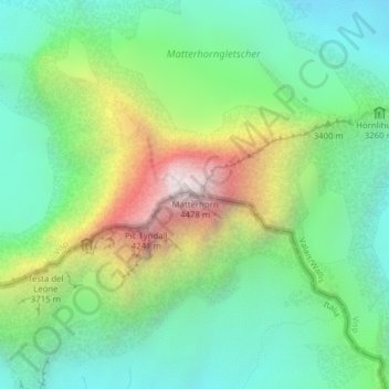
Name: Matterhorn topographic map, elevation, terrain.
Location: Matterhorn, Zermatt, Visp, Valais/Wallis, 3920, Switzerland (45.97640 7.65852 45.97650 7.65862)
Average elevation: 3,296 m
Minimum elevation: 2,762 m
Maximum elevation: 4,389 m
Other topographic maps
Click on a map to view its topography, its elevation and its terrain.
Theodulgletscher
Switzerland > Valais/Wallis > Zermatt
Theodulgletscher, Klein Matterhorn, Trockener Steg, Zermatt, Visp, Valais/Wallis, 3920, Switzerland
Average elevation: 3,228 m
Dufourspitze (Monte Rosa)
Switzerland > Valais/Wallis > Zermatt
Dufourspitze (Monte Rosa), Zermatt, Visp, Valais/Wallis, 3920, Switzerland
Average elevation: 4,033 m
Ober Gabelhorn
Switzerland > Valais/Wallis > Zermatt
Ober Gabelhorn, Zermatt, Visp, Valais/Wallis, 3920, Switzerland
Average elevation: 3,320 m
Pennine Alps
Switzerland > Valais/Wallis > Zermatt
Pennine Alps, Zermatt, Visp, Valais/Wallis, 3920, Switzerland
Average elevation: 3,842 m
Klein Matterhorn
Switzerland > Valais/Wallis > Zermatt
Klein Matterhorn, Zermatt, Visp, Valais/Wallis, 3920, Switzerland
Average elevation: 3,515 m
Dunantspitze
Switzerland > Valais/Wallis > Zermatt
Dunantspitze, Zermatt, Visp, Valais/Wallis, 3920, Switzerland
Average elevation: 4,017 m
Zumsteinspitze
Switzerland > Valais/Wallis > Zermatt
Zumsteinspitze, Zermatt, Visp, Valais/Wallis, 3920, Switzerland
Average elevation: 4,001 m