
Thank you for supporting this site ❤️
Make a donation
Make a donation
Town of Alma topographic map
Click on the map to display elevation.
Thank you for supporting this site ❤️
Make a donation
Make a donation
About this map
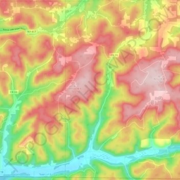
Name: Town of Alma topographic map, elevation, terrain.
Location: Town of Alma, Allegany County, New York, United States (41.99865 -78.07426 42.08685 -77.95546)
Average elevation: 633 m
Minimum elevation: 457 m
Maximum elevation: 780 m
Thank you for supporting this site ❤️
Make a donation
Make a donation
Other topographic maps
Click on a map to view its topography, its elevation and its terrain.
Thank you for supporting this site ❤️
Make a donation
Make a donation
Alfred
United States > New York > Allegany County > Alfred
The elevation of Alfred is about 1,700 feet (520 m) but rises to a high point of 2,355 feet (718 m) at the summit of Jericho Hill just south of the village. The hills greatly affect the weather in the region, which results in quick changes as well as different conditions in neighboring valleys.
Average elevation: 604 m
Thank you for supporting this site ❤️
Make a donation
Make a donation
Thank you for supporting this site ❤️
Make a donation
Make a donation