
Make a donation
Sullivan County topographic map
Click on the map to display elevation.
Make a donation
Sullivan County
Elevation ranges from 2593 ft at North Mountain in Davidson Township to 779 ft on Loyalsock Creek at the Lycoming County line. The county is served by Pennsylvania Route 42, Pennsylvania Route 87, Pennsylvania Route 154, Pennsylvania Route 487, and U.S. Route 220. The major rivers in the county are Loyalsock Creek, Little Loyalsock Creek, Muncy Creek, and Fishing Creek. The majority of the land in Sullivan County is forest, but there is some farmland, especially in the northern part of the county. There are numerous river valleys in the southern and western parts of Sullivan County.
Make a donation
About this map
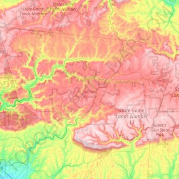
Name: Sullivan County topographic map, elevation, terrain.
Location: Sullivan County, Pennsylvania, United States (41.27570 -76.81394 41.59006 -76.22007)
Average elevation: 491 m
Minimum elevation: 146 m
Maximum elevation: 777 m
Make a donation
Other topographic maps
Click on a map to view its topography, its elevation and its terrain.
Sunshine Hill
United States > Pennsylvania > Fayette County > Nicholson Township
Average elevation: 294 m
Make a donation
Mill Run
United States > Pennsylvania > Blair County > Altoona > Allegheny Furnace
Average elevation: 349 m
Make a donation
Hubbard Mountain
United States > Pennsylvania > Lackawanna County > Scott Township
Average elevation: 503 m
Make a donation
Oakville
United States > Pennsylvania > Cumberland County > North Newton Township
Average elevation: 180 m
Parkland Heights
United States > Pennsylvania > Bucks County > Middletown Township
Average elevation: 45 m
Make a donation
Millers
United States > Pennsylvania > Northampton County > Plainfield Township
Average elevation: 200 m
Rehrersburg
United States > Pennsylvania > Berks County > Tulpehocken Township
Average elevation: 165 m
Martin's Creek
United States > Pennsylvania > Northampton County > Lower Mount Bethel Township > Martins Creek
Average elevation: 152 m
Make a donation
Willow Grove
United States > Pennsylvania > Montgomery County > Upper Moreland Township
Average elevation: 91 m
Make a donation
Williamstown
United States > Pennsylvania > Lehigh County > Washington Township
Average elevation: 178 m
Make a donation
Bob Case Park
United States > Pennsylvania > Montgomery County > Upper Merion Township > King of Prussia > Sweet Briar
Average elevation: 45 m
Rocky Valley
United States > Pennsylvania > Bucks County > Springfield Township
Average elevation: 190 m
Plain Grove
United States > Pennsylvania > Plain Grove Township > Plain Grove
Average elevation: 360 m
Fairfield Heights
United States > Pennsylvania > Indiana County > Burrell Township
Average elevation: 396 m
Make a donation
Eyer
United States > Pennsylvania > Huntingdon County > Warriors Mark Township > Eyer
Average elevation: 380 m
Make a donation
Glenrose
United States > Pennsylvania > Chester County > East Fallowfield Township > Glenrose
Average elevation: 154 m
Audubon
United States > Pennsylvania > Montgomery County > Lower Providence Township > Audubon
Average elevation: 55 m
Make a donation
Gooseberry Hill
United States > Pennsylvania > Sullivan County > Hillsgrove Township
Average elevation: 446 m
Philadelphia
United States > Pennsylvania > Philadelphia County > Philadelphia
Average elevation: 35 m
Spring Ridge
United States > Pennsylvania > Berks County > Spring Township > Spring Ridge
Average elevation: 98 m
Make a donation
Chadds Ford
United States > Pennsylvania > Delaware County > Chadds Ford Township > Chadds Ford
Average elevation: 86 m
Freysville
United States > Pennsylvania > York County > Windsor Township > Freysville
Average elevation: 233 m
Pendle Hill
United States > Pennsylvania > Delaware County > Nether Providence Township
Average elevation: 61 m
Make a donation
Make a donation