
Make a donation
County Wicklow topographic map
Click on the map to display elevation.
Make a donation
County Wicklow
The county experiences a narrow annual temperature range. Typical daytime highs range from 17–22 °C (63–72 °F) throughout the county in July and August, with overnight lows in the 11–14 °C (52–57 °F) range, although temperatures in the mountains can be 5–10 °C (41–50 °F) lower. Mean January temperatures range from 7 °C (45 °F) on the coast to 0 °C (32 °F) at high elevations. Precipitation is fairly evenly distributed throughout the year, although the wettest months (October and November) receive roughly twice as much rain as the driest months (February, March and April). The driest area of Wicklow is the northeast corner of the county, which is protected from the prevailing south-westerly winds by the Wicklow Mountains and receives around 750 mm (30 in) of rainfall per year. The coastal region of County Dublin immediately to the north is the driest location in all of Ireland as a result of the rain shadow created by the mountains.
Make a donation
About this map
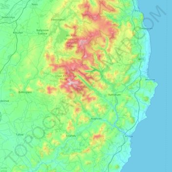
Name: County Wicklow topographic map, elevation, terrain.
Location: County Wicklow, Leinster, Ireland (52.68198 -6.79229 53.23431 -5.99758)
Average elevation: 166 m
Minimum elevation: 0 m
Maximum elevation: 927 m
Make a donation
Other topographic maps
Click on a map to view its topography, its elevation and its terrain.
Great Skellig
Skellig Michael consists of approximately 22 hectares (54 acres) of rock, with its highest point, known as the Spit, 218 m (714 ft) above sea level. The island is defined by its twin peaks and intervening valley (known as Christ's Saddle), which make its landscape steep and inhospitable. It is best known for…
Average elevation: 1 m
Make a donation
Make a donation
Make a donation
Make a donation
Make a donation
Make a donation
Bruree
Ireland > County Limerick > The Municipal District of Cappamore — Kilmallock
Average elevation: 62 m
Make a donation
Make a donation
Make a donation
Make a donation
Make a donation
Make a donation
Limerick
Ireland > County Limerick > Limerick
Limerick's climate is classified as temperate oceanic (Köppen Cfb). Met Éireann maintains a climatological weather station at Shannon Airport, 20 kilometres west of the city in County Clare. Shannon Airport records an average of 977 millimetres of precipitation annually, most of which is rain. Limerick has a…
Average elevation: 10 m
Make a donation
Make a donation
Make a donation
Make a donation
Make a donation
Make a donation
Make a donation
Make a donation
Make a donation
Make a donation