
La Ruinette topographic map
Interactive map
Click on the map to display elevation.
About this map
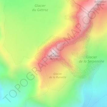
Name: La Ruinette topographic map, elevation, terrain.
Location: La Ruinette, Bagnes, Entremont, Valais, 1934, Suisse (45.97912 7.40022 45.97922 7.40032)
Average elevation: 3,314 m
Minimum elevation: 2,872 m
Maximum elevation: 3,850 m
Other topographic maps
Click on a map to view its topography, its elevation and its terrain.
Combin de Valsorey
Combin de Valsorey, Bagnes, Entremont, Valais, 1934, Suisse
Average elevation: 3,545 m
Glacier d'Otemma
Glacier d'Otemma, Bagnes, Entremont, Valais, 1934, Suisse
Average elevation: 3,127 m
Lac de Mauvoisin
Lac de Mauvoisin, Pont du Lancet, Bagnes, Entremont, Valais, 1934, Suisse
Average elevation: 2,606 m
Dranse de Bagnes
Dranse de Bagnes, Bagnes, Entremont, Valais, 1934, Suisse
Average elevation: 2,551 m