
Thank you for supporting this site ❤️
Make a donation
Make a donation
Llanrhystud topographic map
Click on the map to display elevation.
Thank you for supporting this site ❤️
Make a donation
Make a donation
About this map
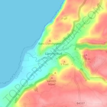
Name: Llanrhystud topographic map, elevation, terrain.
Location: Llanrhystud, Ceredigion, Wales, SY23 5DG, United Kingdom (52.28564 -4.16504 52.32564 -4.12504)
Average elevation: 63 m
Minimum elevation: 0 m
Maximum elevation: 160 m
Thank you for supporting this site ❤️
Make a donation
Make a donation
Other topographic maps
Click on a map to view its topography, its elevation and its terrain.
Thank you for supporting this site ❤️
Make a donation
Make a donation
Thank you for supporting this site ❤️
Make a donation
Make a donation
Thank you for supporting this site ❤️
Make a donation
Make a donation
Newcastle Emlyn Castle
United Kingdom > Wales > Ceredigion > Adpar > Bryndioddef
Average elevation: 78 m
Thank you for supporting this site ❤️
Make a donation
Make a donation