
Thank you for supporting this site ❤️
Make a donation
Make a donation
Ostfildern topographic map
Click on the map to display elevation.
Thank you for supporting this site ❤️
Make a donation
Make a donation
About this map
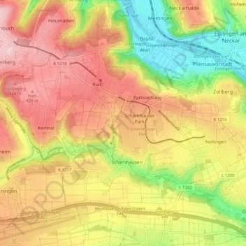
Name: Ostfildern topographic map, elevation, terrain.
Average elevation: 350 m
Minimum elevation: 226 m
Maximum elevation: 454 m
Thank you for supporting this site ❤️
Make a donation
Make a donation
Other topographic maps
Click on a map to view its topography, its elevation and its terrain.
Ruine Reußenstein
Germany > Baden-Württemberg > Landkreis Esslingen > Neidlingen
Average elevation: 675 m
Bernhausen
Germany > Baden-Württemberg > Landkreis Esslingen > Filderstadt > Bernhausen
Average elevation: 382 m
Thank you for supporting this site ❤️
Make a donation
Make a donation