
Thank you for supporting this site ❤️
Make a donation
Make a donation
Ivoševci topographic map
Click on the map to display elevation.
Thank you for supporting this site ❤️
Make a donation
Make a donation
About this map
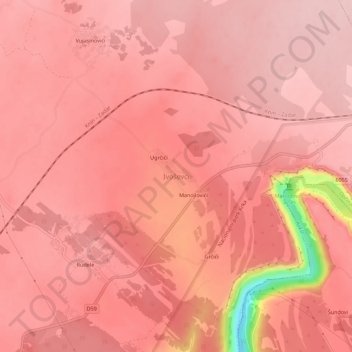
Name: Ivoševci topographic map, elevation, terrain.
Location: Ivoševci, Općina Kistanje, Šibenik-Knin County, Croatia (43.99604 15.98722 44.03604 16.02722)
Average elevation: 241 m
Minimum elevation: 80 m
Maximum elevation: 271 m
Thank you for supporting this site ❤️
Make a donation
Make a donation
Other topographic maps
Click on a map to view its topography, its elevation and its terrain.
Thank you for supporting this site ❤️
Make a donation
Make a donation
Thank you for supporting this site ❤️
Make a donation
Make a donation
Thank you for supporting this site ❤️
Make a donation
Make a donation
Krapanj
Croatia > Šibenik-Knin County > Grad Šibenik > Krapanj
Krapanj is one of the smallest inhabited islands of the Adriatic Sea covering 0.36 km2. It is the lowest island on the Adriatic with an elevation of 1.5m above sea level. Krapanj is 300m offshore at its closest point from the mainland town of Brodarica.
Average elevation: 5 m
Thank you for supporting this site ❤️
Make a donation
Make a donation
Thank you for supporting this site ❤️
Make a donation
Make a donation
Thank you for supporting this site ❤️
Make a donation
Make a donation
Thank you for supporting this site ❤️
Make a donation
Make a donation
Thank you for supporting this site ❤️
Make a donation
Make a donation