
Thank you for supporting this site ❤️
Make a donation
Make a donation
Apozol topographic map
Click on the map to display elevation.
Thank you for supporting this site ❤️
Make a donation
Make a donation
About this map
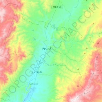
Name: Apozol topographic map, elevation, terrain.
Location: Apozol, Zacatecas, Mexico (21.36179 -103.21965 21.56316 -102.93498)
Average elevation: 1,724 m
Minimum elevation: 1,200 m
Maximum elevation: 2,759 m
Thank you for supporting this site ❤️
Make a donation
Make a donation
Other topographic maps
Click on a map to view its topography, its elevation and its terrain.
Sombrerete
Mexico > Zacatecas > Sombrerete
The region is between the Sierra Madre Occidental and the central highlands of Mexico. The municipality is in a valley is surrounded on all sides by small mountain ranges such as the Sierra de Sombrerete and the Sierra de Santa María with prominent elevations such as the Cerro Grande, Cerro Reyes, Cerro…
Average elevation: 2,401 m
Thank you for supporting this site ❤️
Make a donation
Make a donation
San Antonio de Belén (San Antonio)
Mexico > Zacatecas > Sombrerete > San Agustín
Average elevation: 2,441 m
Thank you for supporting this site ❤️
Make a donation
Make a donation