
Thank you for supporting this site ❤️
Make a donation
Make a donation
Caddo Gap topographic map
Click on the map to display elevation.
Thank you for supporting this site ❤️
Make a donation
Make a donation
About this map
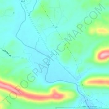
Name: Caddo Gap topographic map, elevation, terrain.
Location: Caddo Gap, Montgomery County, Arkansas, 71935, United States (34.38010 -93.63936 34.42010 -93.59936)
Average elevation: 227 m
Minimum elevation: 178 m
Maximum elevation: 388 m
Thank you for supporting this site ❤️
Make a donation
Make a donation
Other topographic maps
Click on a map to view its topography, its elevation and its terrain.