
Make a donation
Clarksville topographic map
Click on the map to display elevation.
Make a donation
About this map
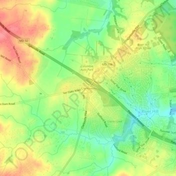
Name: Clarksville topographic map, elevation, terrain.
Average elevation: 134 m
Minimum elevation: 96 m
Maximum elevation: 173 m
Make a donation
Other topographic maps
Click on a map to view its topography, its elevation and its terrain.
Columbia
United States > Maryland > Howard County > Columbia
The primary landforms in Columbia are rolling hills and stream valleys; Columbia's road network is laid out to follow the terrain, with many winding streets and cul-de-sacs. Elevations range from about 200 to 500 feet (61 to 152 m) above sea level. Most of Columbia is drained by the Middle Patuxent and Little…
Average elevation: 113 m
Columbia
United States > Maryland > Howard County > Columbia
The primary landforms in Columbia are rolling hills and stream valleys; Columbia's road network is laid out to follow the terrain, with many winding streets and cul-de-sacs. Elevations range from about 200 to 500 feet (61 to 152 m) above sea level. Most of Columbia is drained by the Middle Patuxent and Little…
Average elevation: 114 m
Howard County Conservancy at Mt. Pleasant
United States > Maryland > Howard County > Columbia
Average elevation: 135 m
Make a donation
Columbia
United States > Maryland > Howard County > Columbia
The primary landforms in Columbia are rolling hills and stream valleys; Columbia's road network is laid out to follow the terrain, with many winding streets and cul-de-sacs. Elevations range from about 200 to 500 feet (61 to 152 m) above sea level. Most of Columbia is drained by the Middle Patuxent and Little…
Average elevation: 114 m