
Thank you for supporting this site ❤️
Make a donation
Make a donation
Bow Street topographic map
Click on the map to display elevation.
Thank you for supporting this site ❤️
Make a donation
Make a donation
About this map
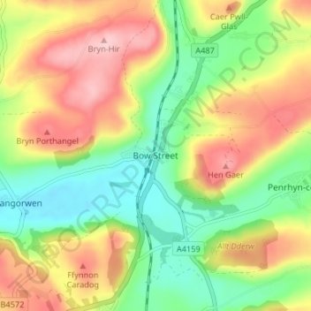
Name: Bow Street topographic map, elevation, terrain.
Location: Bow Street, Ceredigion, Wales, SY24 5BJ, United Kingdom (52.42186 -4.04864 52.46186 -4.00864)
Average elevation: 83 m
Minimum elevation: 7 m
Maximum elevation: 175 m
Thank you for supporting this site ❤️
Make a donation
Make a donation
Other topographic maps
Click on a map to view its topography, its elevation and its terrain.
Thank you for supporting this site ❤️
Make a donation
Make a donation
Thank you for supporting this site ❤️
Make a donation
Make a donation
Newcastle Emlyn Castle
United Kingdom > Wales > Ceredigion > Adpar > Bryndioddef
Average elevation: 78 m
Thank you for supporting this site ❤️
Make a donation
Make a donation
Thank you for supporting this site ❤️
Make a donation
Make a donation