
Thank you for supporting this site ❤️
Make a donation
Make a donation
Le Hohwald topographic map
Click on the map to display elevation.
Thank you for supporting this site ❤️
Make a donation
Make a donation
Le Hohwald
Le Hohwald is a hill village, with altitude above sea level in the commune ranging from 450 meters to nearly 1100 meters, positioned some fifty kilometres to the west-south-west of Strasbourg and some ten kilometres to the south-west of Mont Sainte-Odile. Its position in the lee of mountains protects it from north winds and from many of the frequent fogs and mists that are a feature of the climate elsewhere in Alsace, and supports claims of an unexpectedly benign climate all the year round.
Thank you for supporting this site ❤️
Make a donation
Make a donation
About this map
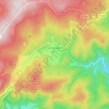
Name: Le Hohwald topographic map, elevation, terrain.
Average elevation: 730 m
Minimum elevation: 358 m
Maximum elevation: 1,048 m
Thank you for supporting this site ❤️
Make a donation
Make a donation
Other topographic maps
Click on a map to view its topography, its elevation and its terrain.
Thank you for supporting this site ❤️
Make a donation
Make a donation
Thank you for supporting this site ❤️
Make a donation
Make a donation