
Make a donation
Bektež topographic map
Click on the map to display elevation.
Make a donation
About this map
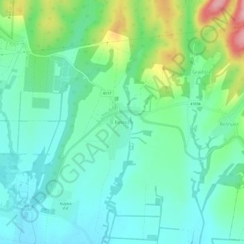
Name: Bektež topographic map, elevation, terrain.
Location: Bektež, Grad Kutjevo, Požega-Slavonia County, Croatia (45.37593 17.90600 45.41593 17.94600)
Average elevation: 194 m
Minimum elevation: 150 m
Maximum elevation: 316 m
Make a donation
Other topographic maps
Click on a map to view its topography, its elevation and its terrain.
Grad Požega
Croatia > Požega-Slavonia County
Požega (elevation: 152 m (499 ft)) is located in the south-western part of the Valley of Požega, or Požega basin, in Croatian: Požeška kotlina. This fertile valley has been important since the antiquity - its Roman name was Vallis Aurea, meaning "golden valley".
Average elevation: 222 m
Make a donation