Geolocate

Garfield topographic map

Interactive map

Click on the map to display elevation.

About this map

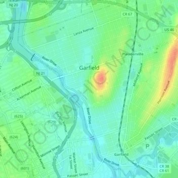
Name: Garfield topographic map, elevation, terrain.

Location: Garfield, Bergen County, New Jersey, 07026, United States (40.86162 -74.13019 40.89366 -74.09196)

Average elevation: 16 m

Minimum elevation: 1 m

Maximum elevation: 50 m

Other topographic maps

Click on a map to view its topography, its elevation and its terrain.

Woodcliff Lake

United States > New Jersey > Bergen County > Woodcliff Lake

Woodcliff Lake, Bergen County, New Jersey, 07677, United States

Average elevation: 84 m

Hackensack

United States > New Jersey > Bergen County > Hackensack

Hackensack, Bergen County, New Jersey, 07601, United States

Average elevation: 18 m

Palisades Park

United States > New Jersey > Bergen County > Palisades Park

Palisades Park, Bergen County, New Jersey, 07650, United States

Average elevation: 35 m

Carlton Hill

United States > New Jersey > Bergen County > East Rutherford > Carlton Hill

Carlton Hill, East Rutherford, Bergen County, New Jersey, 07057, United States

Average elevation: 21 m