
Thank you for supporting this site ❤️
Make a donation
Make a donation
Narsaq topographic map
Click on the map to display elevation.
Thank you for supporting this site ❤️
Make a donation
Make a donation
About this map
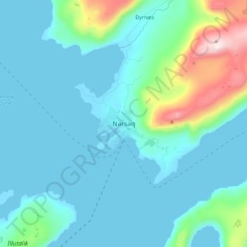
Name: Narsaq topographic map, elevation, terrain.
Location: Narsaq, Kujalleq, 3921, Greenland (60.87275 -46.08527 60.95275 -46.00527)
Average elevation: 117 m
Minimum elevation: -1 m
Maximum elevation: 790 m
Thank you for supporting this site ❤️
Make a donation
Make a donation
Other topographic maps
Click on a map to view its topography, its elevation and its terrain.