
Thank you for supporting this site ❤️
Make a donation
Make a donation
Fontes topographic map
Click on the map to display elevation.
Thank you for supporting this site ❤️
Make a donation
Make a donation
About this map
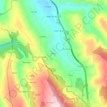
Name: Fontes topographic map, elevation, terrain.
Location: Fontes, Furco, Becerreá, Ancares, Galicia, 27648, España (42.87089 -7.21329 42.91089 -7.17329)
Average elevation: 752 m
Minimum elevation: 560 m
Maximum elevation: 998 m
Thank you for supporting this site ❤️
Make a donation
Make a donation