
Thank you for supporting this site ❤️
Make a donation
Make a donation
Pico da Bandeira topographic map
Click on the map to display elevation.
Thank you for supporting this site ❤️
Make a donation
Make a donation
Pico da Bandeira
Pico da Bandeira is also remarkable for being the Brazilian mountain with the greatest topographic isolation: 2,344 km (1,457 miles). This means that at less than that distance, there is no other point on the surface of the Earth at equal or greater elevation. In the Americas, only Aconcagua, Denali, Pico de Orizaba and Mount Whitney are more topographically isolated than Pico da Bandeira, and in the entire world, there are only 20 more isolated mountains.
Thank you for supporting this site ❤️
Make a donation
Make a donation
About this map
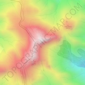
Name: Pico da Bandeira topographic map, elevation, terrain.
Average elevation: 2,488 m
Minimum elevation: 1,976 m
Maximum elevation: 2,865 m
Thank you for supporting this site ❤️
Make a donation
Make a donation