
Thank you for supporting this site ❤️
Make a donation
Make a donation
Thulin topographic map
Click on the map to display elevation.
Thank you for supporting this site ❤️
Make a donation
Make a donation
About this map
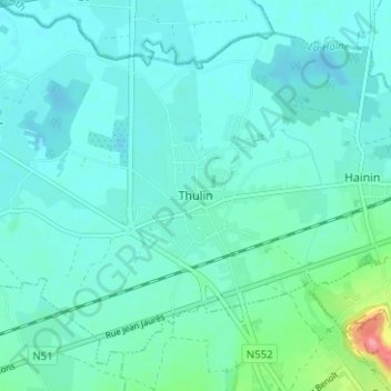
Name: Thulin topographic map, elevation, terrain.
Location: Thulin, Hensies, Mons, Hainaut, Wallonie, 7350, Belgique (50.40928 3.71932 50.44928 3.75932)
Average elevation: 29 m
Minimum elevation: 14 m
Maximum elevation: 114 m
Thank you for supporting this site ❤️
Make a donation
Make a donation
Other topographic maps
Click on a map to view its topography, its elevation and its terrain.
Thank you for supporting this site ❤️
Make a donation
Make a donation