
Thank you for supporting this site ❤️
Make a donation
Make a donation
Puerto Rico topographic map
Click on the map to display elevation.
Thank you for supporting this site ❤️
Make a donation
Make a donation
About this map
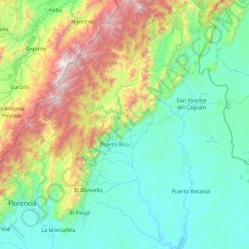
Name: Puerto Rico topographic map, elevation, terrain.
Location: Puerto Rico, Caquetá, RAP Amazonía, Colombia (1.38758 -75.34858 2.62838 -74.78266)
Average elevation: 876 m
Minimum elevation: 207 m
Maximum elevation: 3,444 m
Thank you for supporting this site ❤️
Make a donation
Make a donation
Other topographic maps
Click on a map to view its topography, its elevation and its terrain.
San Vicente del Caguán
Colombia > Caquetá > San Vicente del Caguán > San Vicente del Caguán
Average elevation: 276 m
Thank you for supporting this site ❤️
Make a donation
Make a donation
Thank you for supporting this site ❤️
Make a donation
Make a donation
Thank you for supporting this site ❤️
Make a donation
Make a donation
Thank you for supporting this site ❤️
Make a donation
Make a donation
Thank you for supporting this site ❤️
Make a donation
Make a donation
Thank you for supporting this site ❤️
Make a donation
Make a donation
Thank you for supporting this site ❤️
Make a donation
Make a donation