
Thank you for supporting this site ❤️
Make a donation
Make a donation
Bensheim topographic map
Click on the map to display elevation.
Thank you for supporting this site ❤️
Make a donation
Make a donation
About this map
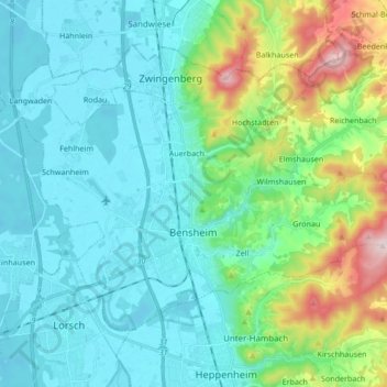
Name: Bensheim topographic map, elevation, terrain.
Location: Bensheim, Kreis Bergstraße, Hesse, 64625, Germany (49.65309 8.54344 49.73029 8.71350)
Average elevation: 189 m
Minimum elevation: 89 m
Maximum elevation: 533 m
Thank you for supporting this site ❤️
Make a donation
Make a donation
Other topographic maps
Click on a map to view its topography, its elevation and its terrain.
Wald-Michelbach
Germany > Hesse > Kreis Bergstraße > Wald-Michelbach > Wald-Michelbach
Average elevation: 396 m