
Lake Burley Griffin topographic map
Interactive map
Click on the map to display elevation.
About this map
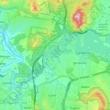
Name: Lake Burley Griffin topographic map, elevation, terrain.
Average elevation: 589 m
Minimum elevation: 508 m
Maximum elevation: 811 m
Charles Robert Scrivener (1855–1923) recommended the site for Canberra in 1909, which was to be a planned capital city for the country. One of the reasons for the location's selection was its ability to store water "for ornamental purposes at reasonable cost"; Scrivener's work had demonstrated that the topography could be used to create a lake through flooding.
Other topographic maps
Click on a map to view its topography, its elevation and its terrain.
Watson
Australia > Australian Capital Territory > Canberra
Watson, District of Canberra Central, Australian Capital Territory, Australia
Average elevation: 613 m
Dickson
Australia > Australian Capital Territory > Canberra
Dickson, Canberra, District of Canberra Central, Australian Capital Territory, 2602, Australia
Average elevation: 589 m
City
Australia > Australian Capital Territory > Canberra
City, Canberra, District of Canberra Central, Australian Capital Territory, 2601, Australia
Average elevation: 570 m
Lyneham
Australia > Australian Capital Territory > Canberra
Lyneham, Canberra, District of Canberra Central, Australian Capital Territory, 2602, Australia
Average elevation: 589 m
Capital Hill
Australia > Australian Capital Territory > Canberra
Capital Hill, Canberra, District of Canberra Central, Australian Capital Territory, 2600, Australia
Average elevation: 582 m
Turner
Australia > Australian Capital Territory > Canberra
Turner, Canberra, District of Canberra Central, Australian Capital Territory, 2612, Australia
Average elevation: 580 m
Parkes
Australia > Australian Capital Territory > Canberra
Parkes, Canberra, District of Canberra Central, Australian Capital Territory, 2600, Australia
Average elevation: 568 m
Rendezvous Creek
Australia > Australian Capital Territory > Canberra
Rendezvous Creek, Canberra, Australian Capital Territory, Australia
Average elevation: 1,157 m
Naas River
Australia > Australian Capital Territory > Canberra
Naas River, Canberra, Australian Capital Territory, Australia
Average elevation: 947 m
Mount Namadgi
Australia > Australian Capital Territory > Canberra
Mount Namadgi, Canberra, Australian Capital Territory, Australia
Average elevation: 1,526 m
Orroral River
Australia > Australian Capital Territory > Canberra
Orroral River, Canberra, Australian Capital Territory, Australia
Average elevation: 1,023 m
Mount Gudgenby
Australia > Australian Capital Territory > Canberra
Mount Gudgenby, Canberra, Australian Capital Territory, Australia
Average elevation: 1,391 m