
Thank you for supporting this site ❤️
Make a donation
Make a donation
Faveraye-Mâchelles topographic map
Click on the map to display elevation.
Thank you for supporting this site ❤️
Make a donation
Make a donation
About this map
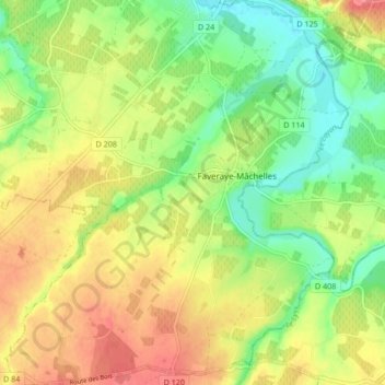
Name: Faveraye-Mâchelles topographic map, elevation, terrain.
Average elevation: 59 m
Minimum elevation: 26 m
Maximum elevation: 95 m
Thank you for supporting this site ❤️
Make a donation
Make a donation
Other topographic maps
Click on a map to view its topography, its elevation and its terrain.
La Ribellerie
France > Pays de la Loire > Maine-et-Loire > Bellevigne-en-Layon
Average elevation: 84 m
Château De Fesles
France > Pays de la Loire > Maine-et-Loire > Bellevigne-en-Layon
Average elevation: 69 m
Les Charlottes
France > Pays de la Loire > Maine-et-Loire > Bellevigne-en-Layon
Average elevation: 58 m
Thank you for supporting this site ❤️
Make a donation
Make a donation
Chasles
France > Pays de la Loire > Maine-et-Loire > Bellevigne-en-Layon > Chasles
Average elevation: 55 m