
Thank you for supporting this site ❤️
Make a donation
Make a donation
Wentzville topographic map
Click on the map to display elevation.
Thank you for supporting this site ❤️
Make a donation
Make a donation
About this map
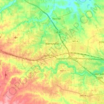
Name: Wentzville topographic map, elevation, terrain.
Location: Wentzville, Saint Charles County, Missouri, United States (38.76130 -90.93922 38.86661 -90.77501)
Average elevation: 183 m
Minimum elevation: 132 m
Maximum elevation: 241 m
Thank you for supporting this site ❤️
Make a donation
Make a donation
Other topographic maps
Click on a map to view its topography, its elevation and its terrain.
Mississippi & Missouri River Confluence Point
United States > Missouri > Saint Charles County > West Alton
Average elevation: 126 m
Thank you for supporting this site ❤️
Make a donation
Make a donation
The Bluffs Lake Dam
United States > Missouri > Saint Charles County > Harvester
Average elevation: 157 m
Thank you for supporting this site ❤️
Make a donation
Make a donation