
Thank you for supporting this site ❤️
Make a donation
Make a donation
West Bay topographic map
Click on the map to display elevation.
Thank you for supporting this site ❤️
Make a donation
Make a donation
About this map
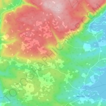
Name: West Bay topographic map, elevation, terrain.
Average elevation: 109 m
Minimum elevation: -1 m
Maximum elevation: 251 m
Thank you for supporting this site ❤️
Make a donation
Make a donation
Other topographic maps
Click on a map to view its topography, its elevation and its terrain.
Mull River
Canada > Nova Scotia > Municipality of the County of Inverness > Mabou
Average elevation: 83 m