
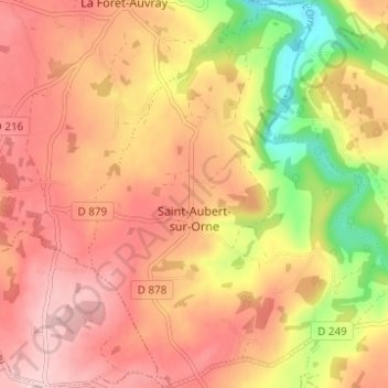
Saint-Aubert-sur-Orne topographic map
Interactive map
Click on the map to display elevation.
About this map
Name: Saint-Aubert-sur-Orne topographic map, elevation, terrain.
Average elevation: 200 m
Minimum elevation: 70 m
Maximum elevation: 279 m
Other topographic maps
Click on a map to view its topography, its elevation and its terrain.
Putanges-Pont-Écrepin
France > Normandie > Orne > Putanges-le-Lac
Putanges-Pont-Écrepin, Putanges-le-Lac, Argentan, Orne, Normandie, France métropolitaine, 61210, France
Average elevation: 186 m
Le Ray
France > Normandie > Orne > Putanges-le-Lac > La Forêt-Auvray
Le Ray, La Forêt-Auvray, Putanges-le-Lac, Argentan, Orne, Normandie, France métropolitaine, 61210, France
Average elevation: 164 m
La Fresnaye-au-Sauvage
France > Normandie > Orne > Putanges-le-Lac
La Fresnaye-au-Sauvage, Putanges-le-Lac, Argentan, Orne, Normandie, France métropolitaine, 61210, France
Average elevation: 214 m
Rabodanges
France > Normandie > Orne > Putanges-le-Lac
Rabodanges, Putanges-le-Lac, Argentan, Orne, Normandie, France métropolitaine, 61210, France
Average elevation: 188 m
Les Courtils
France > Normandie > Orne > Putanges-le-Lac > Putanges-Pont-Écrepin
Les Courtils, Putanges-Pont-Écrepin, Putanges-le-Lac, Argentan, Orne, Normandie, France métropolitaine, 61210, France
Average elevation: 186 m
Les Rotours
France > Normandie > Orne > Putanges-le-Lac
Les Rotours, Putanges-le-Lac, Argentan, Orne, Normandie, France métropolitaine, 61210, France
Average elevation: 191 m
Le Hamel
France > Normandie > Orne > Putanges-le-Lac > La Forêt-Auvray > Le Hamel
Le Hamel, La Forêt-Auvray, Putanges-le-Lac, Argentan, Orne, Normandie, France métropolitaine, 61210, France
Average elevation: 173 m
Le Perrey
France > Normandie > Orne > Putanges-le-Lac > Rabodanges
Le Perrey, Rabodanges, Putanges-le-Lac, Argentan, Orne, Normandie, France métropolitaine, 61210, France
Average elevation: 177 m
Le Chenay
France > Normandie > Orne > Putanges-le-Lac > Putanges-Pont-Écrepin
Le Chenay, Putanges-Pont-Écrepin, Putanges-le-Lac, Argentan, Orne, Normandie, France métropolitaine, 61210, France
Average elevation: 188 m
Sainte-Croix-sur-Orne
France > Normandie > Orne > Putanges-le-Lac
Sainte-Croix-sur-Orne, Putanges-le-Lac, Argentan, Orne, Normandie, France métropolitaine, 61210, France
Average elevation: 186 m