
Thank you for supporting this site ❤️
Make a donation
Make a donation
Fuhrmannsloch topographic map
Click on the map to display elevation.
Thank you for supporting this site ❤️
Make a donation
Make a donation
About this map
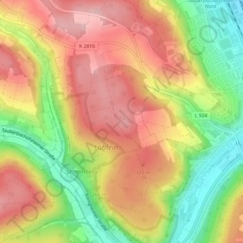
Name: Fuhrmannsloch topographic map, elevation, terrain.
Average elevation: 272 m
Minimum elevation: 178 m
Maximum elevation: 346 m
Thank you for supporting this site ❤️
Make a donation
Make a donation
Other topographic maps
Click on a map to view its topography, its elevation and its terrain.
Impfingen
Deutschland > Baden-Württemberg > Main-Tauber-Kreis > Tauberbischofsheim
Average elevation: 243 m
Leintal
Deutschland > Baden-Württemberg > Main-Tauber-Kreis > Tauberbischofsheim
Average elevation: 237 m
Distelhausen
Deutschland > Baden-Württemberg > Main-Tauber-Kreis > Tauberbischofsheim
Average elevation: 251 m
Hochhausen
Deutschland > Baden-Württemberg > Main-Tauber-Kreis > Tauberbischofsheim
Average elevation: 245 m
Thank you for supporting this site ❤️
Make a donation
Make a donation