
Schleinikon topographic map
Interactive map
Click on the map to display elevation.
About this map
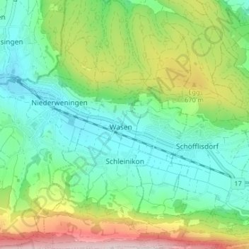
Name: Schleinikon topographic map, elevation, terrain.
Location: Schleinikon, Bezirk Dielsdorf, Zurich, 8165, Suisse (47.48162 8.37584 47.52574 8.40604)
Average elevation: 566 m
Minimum elevation: 441 m
Maximum elevation: 834 m
Other topographic maps
Click on a map to view its topography, its elevation and its terrain.
Oberhasli
Suisse > Zurich > Bezirk Dielsdorf > Niederhasli
Oberhasli, Niederhasli, Bezirk Dielsdorf, Zurich, 8156, Suisse
Average elevation: 449 m