
Thank you for supporting this site ❤️
Make a donation
Make a donation
Eremieni topographic map
Click on the map to display elevation.
Thank you for supporting this site ❤️
Make a donation
Make a donation
About this map
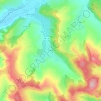
Name: Eremieni topographic map, elevation, terrain.
Location: Eremieni, Bereni, Mureș, 547391, Romania (46.51642 24.85158 46.55642 24.89158)
Average elevation: 452 m
Minimum elevation: 357 m
Maximum elevation: 581 m
Thank you for supporting this site ❤️
Make a donation
Make a donation
Other topographic maps
Click on a map to view its topography, its elevation and its terrain.
Târgu Mureș
The old City Hall was built in 1906–1907 after the construction plans of Márcell Komor and Dezső Jakab. The entrance area, including the corridor and the staircase leading to the first floor, is the most representative in this regard. The ribbed stellar vaults that cover this area were inspired by Gothic…
Average elevation: 357 m